My previous post seems to end the digital journal on a light note but I guess the final entry should be on a reflection of what I have learned about cities, planning and public spaces.
First of all I begin writing this blog with thought of exploring radical ideas on the future of city planning. However, as I proceed with writing this blog, my attention turned to something that is more realistic and deals with current issues of urban planning. I guess what I have learned from my experience of writing this blog is that urban planning is not just about the urban form. It also deals with planning policies, the people, the role of citizens in urban planning, the effect of infrastructure on city planning and economic flows. As an architecture student, I enter this course with the primary objective of learning about urban forms but I end up learning more about other aspects in urban planning and the city in more ways than I could have imagined.
Writing this blog also reminded me of the problems of urban planning back in my home country of Malaysia as well as my passion for user-generated urbanism which I wrote about quite a lot in this blog. Additionally, I was able to uncover a few urban planning issues right here in Sydney. I also realized that I am interested in studying the virtual cities found in movies and compare it to cities in the real world.
I believe that the knowledge and experience I have gained through writing this blog as well as taking this course will provide a wider range of knowledge for my journey in becoming an architect. I may have left out some learning outcomes but I am sure that over time, I will come to realize that my future experience will continue to remind me the lessons I have learned through this course and assignment.
Sunday, May 25, 2014
Wednesday, May 21, 2014
New York New York
I have written quite a few posts on different cities but the
city that I would love to visit most has to be New York. The thought of New
York came to my mind while I am working on my studio assignment listening to
some music. The song “New York Minute” by Don Henley and “New York, New York”
performed by Frank Sinatra, Gene Kelly and Jules Munshin for the musical “On
The Town” played back to back on my music library. While I never had the chance
to visit New York yet, the lyrics from these songs provide some hints of what
New York might offer even after all the so many years since the release of both
songs. Both the songs depicts New York as a fast paced city where “Everything
can change, in a New York minute” and that the city has plenty of things to do.
I sure wish that this is true when I finally visit New York.
In addition to the “New York, New York” Sinatra also
performed another song of the same title.
There are plenty of other songs that is dedicated to a
particular city such as:
Friday, May 16, 2014
Density, Sprawl and Float
I find this week’s class and readings to be very
interesting. As an architecture student, I have always held the belief that the
compact and dense living in urban areas is a sustainable method of living.
While The Compact City Fallacy is a good read, I must admit that my knowledge
of sustainable living in terms of density is fairly limited and it is difficult
for me to fully agree with either side of an argument. Instead of posting an
analysis with limited knowledge on the subject area, I thought I could post
some examples of hyper-density living which I find interesting as case studies
of extreme density that makes the living condition unsafe and perhaps not
sustainable.
 |
| The Kowloon Walled City in Hong Kong |
 |
| Rocinha, the largest Favela in Brazil |
While the Kowloon Walled City and the Favelas are not the
best residential types, I find that sometimes the economic conditions or the
natural environment of the city forces the emergence of high density housing.
For example, the HDB flats in Singapore is direct consequent of the shortage of
land in the country. This made me think of examples that could solve the issue
of shortage of land. Below are videos of some examples of how it could be done.
Float!
Wednesday, May 7, 2014
Sydney vs Melbourne
During the semester break, some of my friends from Melbourne
came to Sydney for a visit. While they were here, they pointed out several
differences between the city of Melbourne and Sydney. I had the chance to stay
in both cities during my studies in Australia and most of my friends would ask
if I prefer Sydney over Melbourne. It is easy to compare the two cities as it
is very different.
First of all, Melbourne was planned based on the grid layout
whereas Sydney is more of an organic city mostly due to its topography. This
has significant effect on the two cities as Melbourne is inevitably more
structured and organized in its layout. As a result, the public transport
system in the CBD is far superior to that in Sydney.
The grid planning also makes name of the streets in
Melbourne easier to remember for me. I was only there for a year but I still
remember the names of every street in Melbourne but still having trouble with
the names of streets in Sydney. The streets in Melbourne also have very
distinct identity to it. For example, Spencer Street is the transportation hub
with Southern Cross station spanning the most part of the street. Colins Street
is home to boutiques of high fashion, Little Bourke Street is Chinatown, Lygon
Street is the food street and Swanston Street is the main street where most
international students spend their time on perhaps because it links Melbourne
University and RMIT University to most of the student residential and major
shopping complexes such as QV and Melbourne Central. On the other hand, George
Street in Sydney acts as the main spine of the city but I fail to elaborate
more on the role it plays in the CBD to my visiting friends. In addition, the
other streets around Sydney also lacks a distinctive identity to it other than
Oxford Street.
While the structured layout and clear identity in the
streets of Melbourne makes it easy to navigate and identify, it also makes it
less interesting as you know what to expect if you are to meet someone in an
allocated street. In Sydney however, it is more interesting as you can wander
around every street while still having different options in terms of activity.
Sydney feels like an interesting maze where every corner could offer something unpredictable
whereas in Melbourne, the clear mental maps makes every turn of a corner
predictable. Generally, I feel that the speed of lifestyle is much faster in
Sydney as compared to Melbourne.
The urban fabric of Melbourne ranges from all types of
colours and styles of architecture whereas in Sydney, as my friends put it, is
old and bland. Despite the less picturesque environment, I find Sydney
strangely comforting. This is perhaps the messiness and the hustle and bustle reminds
me of Kuala Lumpur. When asked to compare the two cities of Melbourne and
Sydney in a nutshell, I always compare Melbourne to me more alike to a European
city and Sydney to an Asian city. It is a fact that Melbourne is a more scenic
city but I am more accustomed to the hustle and bustle of Sydney.
The one aspect of Sydney that my friends seems to be amazed
with is the weather. They are all drawn to the clear blue skies and moderate
temperature of Sydney. I must admit that the climate is a huge factor I decided
to move from Melbourne to Sydney. While having the discussion of climate and
weather of a city with my friends, it reminded me on William Cronon’s reading
on Chicago where the natural topography and landscape plays an important role
in the development of a city. Speaking from personal experience, I believe that the natural environment
is also affects the city in terms of drawing in tourists and attracting
potential migrants to the city.
Friday, May 2, 2014
Blocking the Casbah
The situation in Cahill Expressway reminded me of a project
by Le Corbusier. The segregating form of Cahill Expressway is very much similar
to Corbusier’s masterplan in Algiers where he uses road infrastructure as a
separating component in his masterplan. While the planners for Sydney did not
intend to have Cahill Expressway to split the CBD into different components,
Corbusier did so intentionally in Algiers.
 |
| Le Corbusier's masterplan in Algiers |
Corbusier’s masterplan in Algiers consisted of three main
elements as shown in the diagram below: a new business district on the Cape of
Algiers (at the tip of the Casbah) consisting of cargo ports (blue), an
elevated highway arcing connecting suburban blocks containing fourteen
residential levels beneath it towards the industrial zones (yellow) and a
curvilinear residential block with road on top of the blocks of residential
(red).

The viaduct highway connects the residential zones to the
industrial zones bypassing the Casbah beneath it. The curvilinear residential
blocks acts as a wall that separates the Casbah and the business districts.
This is done consciously by Le Corbusier to marginalize the Casbah.
Planners often think of road infrastructure as a means to
connect different points. However, we should also be aware that these huge
structures could also act as a segregating component for better or worse.
Saturday, April 26, 2014
Cahill Expressway
Following my previous post on Railway Square, I thought that
I would post on another area of the CBD where I have been visiting quite a lot
lately after my observation studies in Town Hall. I usually walk towards
Circular Quay for the evening view and sometimes I walk from the Botanical
Gardens to Observatory Hill along Cahill Expressway.
During my walks, I realized that the Cahill Expressway has
split the zoning of this area into four different parts: The Northern part of
Sydney CBD which terminates at the Circular Quay Station, the promenade area
ranging from Sydney Opera House to the MCA in the opposite side of Circular
Quay Station, The Rock and Observatory Hill. We usually identify road
infrastructures as a means to connect from one point to another but the Cahill
Expressway acts also as a segregating component in Sydney. It is not to
different from the examples given in my earlier posts regarding KL Sentral and
Mid Valley City in Malaysia where the road infrastructure acts as a “wall” that
segregates two different parts of development. I have never really thought of
Cahill Expressway in any other way except that it destroys the view from the
CBD toward the Sydney Opera House. Below is a diagram I did to indicate the
form of Cahill Expressway and how it acts as a segregating agent.

While walking from Botanical Gardens towards Observatory
Hill, I always find it annoying as I have to get down from Cahill Expressway to
The Rock before navigating my way through the laneways towards Observatory
Hill. It is not a smooth flow of travel and this again shows how Cahill
Expressway has divided the city into different parts. It is a shame considering
that it has the potential of connecting the two green areas of Sydney which is
the Botanical Gardens and Observatory Hill. While Botanical Gardens is a busy
tourist attraction, the Observatory Hill is a hidden gem of Sydney. I believe
that if the route towards Observatory Hill have an easier access, the place
would be filled with tourists. Even tourists that travels to The Rock are
oblivious to the existence of Observatory Hill behind the wall of concrete
formed by the Cahill Expressway.
Though it is a hassle to travel from Botanical Gardens
towards Observatory Hill, I realized that it is much easier to travel by foot
as compared to the cyclists. While there are bicycle tracks along Cahill
Expressway, the track leads cyclists from Botanical Gardens to North Sydney
along Harbour Bridge. Cyclist will need to stop cycling and carry their bicycle
at one point if they were to cut across and get to Observatory Hill. While
watching cyclist carrying their bikes, it reminded me of the conversation
during the walking tour of seamlessness in the city to cater for cyclist and
skaters. The Cahill Expressway has made cycling and skating around the area to
be very inconvenient. Below is some diagrams I did to highlight the some of the
points I have mentioned.

Friday, April 18, 2014
Railway Square Observation
I have been travelling a lot to the CBD lately to do my city
observation assignment in Town Hall. I usually travel to Central before moving
North towards Town Hall along George Street. During my stay in Railway Square,
I have observed a few things that I thought could be interesting to post on as
an exercise for my city observation assignment.
The Railway Square precinct is an area with a rich history
and a well-defined function as a transportation hub. Railway Square acts as a
gateway into the CBD and this is represented in the built fabric of the
precinct. As a result the buildings are relative low rise and step up towards
the city. Wide streets and an expanse of open area at the main intersection
create a funnel effect as you enter the CBD which feels much more confined.
I find that there are some shortcomings in the area in terms
of pedestrian amenity in conjunction with high traffic movements and low
pedestrian priority. A clear trend of very short lengths of time being spent in
the area by visitors has given the precinct the identity of a thoroughfare
rather than a destination that people want to stay in.
The transport orientated nature of the infrastructure in the
precinct functions sufficiently for current usage but with increasing patronage
of public transport and the potential for the introduction of light rail
through the precinct in the future it is evident that existing infrastructure
will not be able to cope.
Analysis of the demographics and consideration of numbers of
commuters visiting the area has revealed several issues which need to be
addressed. High levels of shared student accommodation and high unemployment in
the area contributes to the definition as a growing region of lower socio
economic development. These levels are directly related to the close proximity
of large scale educational facilities and have shaped the usage of the precinct.
A high density of heritage buildings adds a unique sense of
history to the area. Sandstone and bricks are visible cues to the past and form
a rich pallete of textures which are placed alongside recent developments of
glass and steel. This juxtaposition of materials and design styles helps to
integrate the spaces and buildings with one another and forms a single
character for the whole precinct.
Some parts of precinct have grown in scale to accommodate a
growing student population and to capitalize on the close proximity to
transport connections. However, consistently similar sized buildings reduces the
impact of any single building as a landmark. This consistency has created an
uninterrupted wall of buildings around a central space. The central space is
interrupted by an architectural intervention of glass and steel. The railway
square bus interchange is the heart of the precinct and facilitates the major
transport and pedestrian movements of the area.
An underground link creates a link from Central station
across Lee and George Streets to the bus interchange, the TAFE building and
onwards towards Darling Harbour. This vertical layering of amenity allows for
separation of modes of transport increasing safety and creating a unique
pedestrian experience.
There is very little street furniture in the area provoking
people to resort to resting on stairways and contributes to the identity of the
area as a thoroughfare rather than a destination.
Generally speaking, the precinct is characterized by
tertiary educational uses with UTS, TAFE and the transportation terminal. The
area is bookended by hotels located on the northern and southern ends of the
site. The buildings of educational use are located on the western side of
George Street with retail on the ground floor. The office buildings are
clustered near the entrance to Central Station to the East.
The precinct is an overlapping space of many different uses
but there is a change of dominant function throughout different times of day
and different days of the week. Central Station and the Railway Square bus
interchange dominate the usage of area especially at the peak times of the day;
between 8 - 10 am in the morning and 5 - 6pm in the afternoon. Generally,
working days are busier than weekends. In the morning and evening, transportation
usages dominated this area, however at noon, retail and plazas become more
dominant.
Sunday, April 13, 2014
Public Spaces, Private Spaces
I took the opportunity to travel around to other suburbs in
Sydney during the semester break. I am writing this post in a café in Rozelle while
waiting for my friends to arrive to conduct a site visit. Opposite the road
where I was sitting, there is a school, the Rozelle Public School. During the
weekends, the school compound is being used as a weekend market. This got me
thinking on the definition of public spaces and private spaces. It is probably
because I was reading on Nolli’s Plan last week.
The public spaces in Rozelle would be made up of the café spots
along the shopping strip in either side of Darling Street. I would define cafes
as public space as it is a place where people meet and interact despite not
located outdoor. In fact, I feel that cafes has now become the dominant “public
space” as oppose to the usual public squares and marketplace that used to be
the definition of a public space. It is a sad phenomenon that people are now so
drawn to the café culture where it has elevated the status of cafes to public
space, at least as defined by me. It is also ironic to condemn the café culture
while seating in one but the truth is I find that the more dominant places like
Starbucks become, the less likely public squares are likely to be able to
attract and gather people.
Looking across the road, the marketplace is definitely a
public space for the people in Rozelle. However, during the weekdays, it is not
open to the public. It is interesting that the school shifts from weekends to
weekdays in its role of a public or private space. Another thing that comes to
mind is that the definition of a public space may differ from kids and adults.
The cafes are generally considered as public spaces for adults but the kids
studying in Rozelle Public School are all younger than the age of 12 since it
is a primary school. Do the definition of public space in the cafes along
Darling Street extend to the kids? I believe that it would not. On the other
hand, the open compounds around the school areas are the public spaces from the
kids’ point of view whereas for the adults, the area is out of bounds during
school hours.
The post-office next to the school reminds me of a
discussion I had with my friends a while back. Post-offices and libraries are
examples of public buildings which has been around for a long time to provide communication
and books. However, the growing importance of internet in our daily lives and
the speed of which internet allows for communication and access to knowledge
may change the role of public buildings such as post-offices and libraries.
Email has for the most part replaced hand-written letters and the transfer of
documents. The online resources and innovation such as kindle and ebooks may
slowly replace the need to go to a library to access any information. The
internet itself is a source of unlimited information. The growing trend of
online shopping may also slowly replace the need to have a shopping mall. The
growth and the reliance on the internet may one day replace the need of public
buildings and public spaces. It is a frightening thought that in the future,
there may not be any public buildings left. Perhaps the Nolli Plan of the
future will only be a diagram consisting of black boxes. Or perhaps (and
hopefully) not.
Monday, April 7, 2014
The Lion City
My last post touches on the growth of a city and town and
the effect on the reliance on one agent of resource to support the growth. One
of the country that always kept me thinking on the rapid growth of development
despite having little to no natural resources is Singapore. Singapore was once
part of Malaysia and when they were expelled from the country in 1965, the then
Singaporean Prime Minister Lee Kuan Yew broke down in tears as the newly formed
country of Singapore faces uncertainty in the future. Fast forward to 2014 and
Singapore is now the most developed country in the South East Asian region.
The rapid rise of Singapore as a developed nation owes much
to the fast-acting and planning during the initial years of its formation to
overcome its short-comings. The lack of natural resources was overcome with
development in other sectors such as entrepot trading and manufacturing to
maintain its economy. Singapore is a prime example of a modern-day city that
relies on trading and manufacturing to overcome the lack of natural resources.
The diversified economy of Singapore is a strategy implemented as a vital
source for growth despite its size as a country.
The recent development of Marina Bay Sands in Singapore is
also a strategy to reduce the outgoing of capital to its neighbouring country
of Malaysia. Before, Singaporeans travel extensively to Malaysia for the casino
in Genting Highland and this has benefited Malaysia in more ways than one. The
effect of this can be seen in the land ownership in the town of Malacca where
the heritage-listed shop lots along Heeran Street in Malacca are owned mostly
by Singaporeans. Located in between Singapore and Genting Highlands, Malacca
was a convenient stop-over for Singaporeans. However, since the opening of
Marina Bay Sands in Singapore, the tourist industry in Malacca and Genting
Highlands slowed down significantly.
Marina Bay developments are built on reclaimed land to
overcome the land shortage issue in the country. This was not the first time
that Singapore resorted to reclaimed land to cater for new developments and
probably won’t be the last. There are other measures taken to overcome the
shortage of buildable lands in the country. One of it is the public housing policy
that is pro-density living introduced by the Housing and Development Board
(HDB). High-rise HDB flats are a common sight in Singapore and it houses more
than 80% of its population. I find that the HDB flats area good strategy to
overcome the shortage of land for residential units while able to prevent slums
and squatter housings.
The public transportation system is also build around the
idea of dense population in the small country. To minimize land congestion on
the ground level, the main public transportation system, the MRT, are located
below ground in the city center. As a result, there are many shopping malls
that is located underground to link to the train stations below ground.
Travelling around the city center in Singapore, I find that people spent more
time below ground than they do on street levels discounting the time where they
are in the office or at home.
Saturday, April 5, 2014
What Makes a City?
I looked back to my class notes from a couple of weeks ago
and I found that I have written down a question that was posed during the
class: What makes a city? I remember that one of the key point mentioned in
class was that a city do not hold a single role, rather it has multiple
functions that made it self-sustaining. One of my peer gave the example of
Detroit where the city used to be the center of the automobile industry. Once
that was taken away due to alternative places to develop the automobile industry,
Detroit was soon on the decline.
I never had the opportunity to visit Detroit and to
experience first-hand on the current status of Detroit. However, I had the
opportunity to visit other towns in Australia and Malaysia that was once a
significant area of growth in the country but suffered massive decline due to
the fall of the industry in which the town is known for.
Bendigo in Victoria was once a significant boomtown in
Australia due to the gold rush era in the mid to late 19th Century.
However, the population soon decline as the gold mining operations were
reduced. However, Bendigo was able to recover from the growth slump by using
the rich historical culture and turning it into a tourist attraction. In
addition, it has ventured from a mining town to a commercial precinct that
relies on commerce and education sector on top of tourism as the main
industries.
Another town that suffered a growth slump similar to Bendigo
and Detroit is one I visited in Pahang, Malaysia called Sungai Lembing. It was
one of the major producer of tin and the town benefited from having the largest
and deepest tin mine in the world during its heyday. It was once one of the
richest town in Malaysia. The fortune of the town change significantly once the
price of tin dropped in the mid 1980s and Sungai Lembing was on a sharp decline
ever since. Today, it is a quiet and forgotten town despite locating just 42km
away from Kuantan, the capital town in Pahang.
The growth of the city or town depends heavily on the fate
of the major industries it is known for. The more diversified the city is the
lower the chance of the city suffering from growth decline if one of the
industry were to collapse. On the other hand, if the city or town relies
heavily on a single major industry to support the growth as in the case in
Sungai Lembing, chances are that the fate of the town will decline as soon as
the industry were to collapse.
Friday, April 4, 2014
User-Generated Urbanism
The urban designers and planners can attempt to design and
plan for a city or a place that is performing effectively and has high level of
livability and comfort. However, there are always area for improvement and in
my personal experience from Better Cities and from Phil Stubbs’ talk on Better
Block, I have learned that the community can sometimes provide better insight
on what a place need as they are the ones who are using the space and experiencing
the day to day changes.
I found this link that talks about User-Generated Urbanism
The idea of crowd-sourcing in architecture and urban
planning is beginning to take shape as more and more organization like Better
Block and Better Cities begin to form. However, it is not a concept which is
widely discussed in the built environment community. I felt that the people in
the planning and architecture field feels the need for them to be responsible
for the design for the people and the public should remain as passive
participants as users in the place designed for them. This could probably be
down to egoism. In the field of architecture, it is widely accepted that
architects are egoistic beings and every good architecture should have ego. This
could be the result of the modernist era school of thought where the older
generation architects are taught to be master-builders in the mould of Frank
Lloyd Wright, who famously rearrange the furniture of houses he visits as he
feels he knows better as a designer compared to the layman. He could be right
to think so but the times has change and the character of Howard Roark may no
longer work in a world where open-source and community-based society reign
supreme over individuality.
I recall an architect from Thailand called Patama Roonrakwit
who I had the pleasure of meeting and attending one of her talks. She conduct
her practice as an architect in the role of facilitator in a user-generated
design in the community. During her talk, she was bombarded with questions
which doubted her role and definition as an architect due to her unconventional
methods of design. The feedback given that day on her methods made me realize that
the building community is not ready to accept an open source design method that
involves the users and clients. It also made me realize that Patama could pave
way for a new form or architectural practice that actively engage the community
to take part in the process of design which is not wrong either. Below is a
video link of an interview with Patama which truly inspired me.
Tuesday, April 1, 2014
Megacity and Citizen’s Needs
I found this clip on Youtube when I was looking for
inspiration for my design studio project and thought it is suitable for a post
here. The clip is a trailer for a documentary called “The Human Scale”.
What caught my attention was that it talks about Jan Gehl
and his vision and philosophy on city planning. Gehl Architects are one of my
favourite reference whenever I deal with design studio on an urban scale. I
hold a personal believe that architecture and urban planning should center on
the need of the people using the space instead of being driven by financial
capital of the developer. Perhaps this is why I am interested in organization
such as Better Cities and I usually participate in their events in Malaysia
especially those which brings together communities and ask them what their
preference in terms of improving their neighbourhood are.
The happiness of the people are always the determining
factor of a successful city planning. Then why not make them the core studies
when we are doing an analysis on urban planning. It is important that we
understand how people use and react to the space around them especially in the
urban context. Their needs differs from one culture to another and designers
and planners need to identify the cultural identity of a place and the
demographics of the place in order to cater to the need of the people in their
projects. I find that the most effective way to do so is to map the
demographics, social and cultural patterns and the zoning and building typology
of the site in varying scale. I model this method from the practice of Gehl Architects’
Public Space Public Life where I think they did an excellent job in breaking
down the analysis of a place to different components and presented it in the
forms of maps and data. However, the data presented has very little to do with
planning policy and regulation. Rather, the focus is on human behavior and this
is what I find interesting with their analysis.
Saturday, March 29, 2014
Metropolis
I have been writing and thinking a lot about Malaysia
lately. Even when I was watching one of my favourite movie, my thoughts are
with how it resembles the situation in my country. Fritz Lang’s Metropolis
depicts a futuristic city where the city is structured in vertical layers according
to the different social strata. Released in 1927, I am always left impressed on
Lang’s predicted the progress of social and cultural contexts of the future.
The vision of the future presented by Lang is of the society that relishes on
its accomplishments while a substantial part of the population is subjected to
a new form of slavery to benefit the few elites. It is interesting for me that
Lang uses architecture as an extension
of those profound inequalities, where the labourers was confined to the
underworld white the rest enjoyed a luxury lifestyle with monumental structures
that towered one over the other as if they were trees seeking for light in a
dense forest. At the center of the city was the tallest tower, home of the
governmental offices and the source of all oppression and discrimination.
Interestingly from the point of urbanism and corporation, Lang predicted that
the powerful and rich would seek for glorification by erecting monumental
structures that represents powerful statements to their success and financial
prowess. Metropolis also predicted the continuation of a global trend that
sought for large, highly dense urban centers. The segregation Lang showed in
Metropolis between the labor class and the city dwellers is exaggerated, but
nevertheless acts as a powerful metaphor as the clear separation that exists in
today’s cities where neighborhoods have become divided in terms of class, race
and even religion.
How it reminds me of the situation in Malaysia is that
the country is also divided by different social strata and Kuala Lumpur
represents the large highly-dense urban center which is segregated from other
states that was left in underdevelopment. As a KL native growing up in
Malaysia, I am used to the first class facilities that the city has to offer
and I have always assumed that Malaysia is a country which is comparable with
any advance country around the world. This view of mine changed when I acquired
my driving license and travel around other towns and cities in Malaysia. The
disparity between the other cities in Malaysia and Kuala Lumpur is so wide that
it took me by shock. Further studies and analysis over the years made me realized
that the other states in Malaysia are not poor by default but rather their
resources are poured into the development in KL. The city of KL is almost like
an economic blackhole in Malaysia where it sucked all resources around it to
develop the city of KL into the current state. Looking at the bigger picture,
other states and towns are actually suffering from the development in KL. Take
for example the state of Sarawak, the state with the richest natural resources
but one which is suffering from the lowest development growth. As a result,
people from the other states in Malaysia move to KL or to other countries for
job opportunities and/or better living conditions. In the long run, it may not
be a sustainable trend as it will result in the towns and states to be
abandoned and left to dry until it becomes a ghost town. If that were to
happen, this would affect the capital city as well as there will be no support
coming in from the other states and cities. In my opinion, I don’t think that
any country will survive with a single highly developed capital city without
having secondary cities or satellite cities that share the burden of developing
a country. In order to move forward, and to achieve Vision 2020 (an ideal
introduced by former Prime Minister Tun Mahathir in 1991 to have the nation
achieve a self-sufficient industrialized nation by year 2020) the nation would
require a more balanced growth across the country.
Another movie which can be used as reference for the
situation in Malaysia is perhaps The Hunger Games with its different zones and
layers of social strata as you move away from the capital. The further you move
away from the city center the poorer the citizens are. The layout of the
virtual world in Hunger Games is perhaps a good model of Von Thunen model of
city center. What separates the virtual world in the Hunger Games and the
situation in Malaysia is the lack of a power-crazed dictator that controlled
everything in the realm by segregating the different zones. Or perhaps it is
not so much different after all, I say no more.
Thursday, March 27, 2014
Archipelago KL
The ring roads in KL is not just a planning concept on a macro scale but developers in Malaysia are quick to adopt the idea of roads surrounding the center concept. The two fairly recent development in KL in KL Sentral and Mid Valley city are examples of that. The two projects are island of its own development, having multiple entries from the perimeter of the encircling road to the center of mix-developments of hotels, offices, residential, transportation hub and shopping malls. This trend has caused the city of KL to have developments that forms an archipelago of a mix-use development that is separated from its surrounding context. Subsequently, as discussed in the previous post, this caused major traffic congestions due to the high influx of cars moving in and out of the “island”. More importantly, this has caused KL to move in a direction where it is less pedestrian-friendly than it ever was.
KL Sentral was developed with the objective of being the gateway to the city for international tourist and visitors. It is a transportation hub where all major public transportation system meets. However, this “gateway” to the city is located on the peripheral of the city; and tourists and travelers will then change the transportation mode to their next destination, most frequently a cab which cause further traffic congestion on the road. This “gateway” act more like a transit hub as it is locked in an island of its own by the surrounding roads and detached from its surroundings which prompted the reliance of other transportation mode to move the travelers around. The idea of walking out of the island of KL Sentral is not impossible but it is not entire pedestrian-friendly either. This is a wasted opportunity to promote the beauty and charm of KL as KL Sentral is actually located in between the Royal Botanic Garden and Brickfields which is the center of a cultural hub for the Indian community. In order to walk from KL Sentral to the two tourist attraction spots will require the user to walk on the road shared with cars and pedestrian will need to cross multiple roads with heavy traffic flow. The implementation of traffic lights to allow for pedestrian to move along KL Sentral, Brickfields and the Royal Botanic Garden caused more harm than good. This is because the walkways are very unfriendly and people seldom travel on them but the traffic lights are implemented which stops the already congested traffic every several minutes.
 |
| KL Sentral Development model showing the perimeter road that sets the boundary |
Similarly in Mid Valley City, home to the biggest shopping mall in Malaysia, which is located at the center of multiple residential areas. The layout of Mid Valley City is not catered for the surrounding residential zones to have a clear access. Again the boundary set by the roads encircling Mid Valley City, much like the ones surrounding KL Sentral, encouraged visitors to travel by car in order to access the shopping malls. This has caused residents who live 10 minutes walk away from Mid Valley City to get on their car instead of walking there for better and more comfortable access.
 |
| Aerial view of Mid Valley City showing the boundary set by the roads encircling it |
The idea of archipelago development is not limited to major mix-use development in KL. The habit of travelling by car in KL as well as the paranoia surrounding the safety and well-being in every Malaysian has prompted the rise of popularity in the gated-community residential zones. This is rarely seen in European countries or Australia for that matter as the people are more accustomed to travelling by bicycle or by walking without the need for constant wariness to look over their shoulders and worry about their safety.
The result of the reliance on automobile, the concern for safety and a climate that does not promote long-distance pedestrian travel has caused more and more walled development to arise in Malaysia. As we go along this trend of development, the cities in Malaysia will soon be made up of different zones set apart by a boundary formed by wall-fences and roads. Subsequently, people will rely on cars to get around more so than ever and this would amplify the problem of traffic congestions in KL even more. The problems surrounding the cities in Malaysia could be solved by overcoming the growing number of automobile users but the method of which to do so may require long-term strategic planning. The improvement of the public transportation system is a good start and controlling the use of cars into the city such as demonstrated in Singapore could help to improve the traffic conditions as well.
Tuesday, March 25, 2014
My City, My Car
Following my previous post about Malaysia, I thought of
writing a few more posts on the country which I grew up and am familiar with. Growing
up in Kuala Lumpur, I am very familiar with the city itself as well as the
scent of my car. This is because I spent as much time in my car as I do walking
in the streets of KL if not more. If anyone were to make an appointment with a
Malaysian, chances are that he or she will be late. It is a usual occurrence in
Malaysia. This has much to do with the attitude of Malaysian as well as the way
the cities are planned and how we were brought up in the norm of delays due to
traffic. The traffic in KL is on issue that is a constant topic of discussions
among Malaysian next to food. There are several reasons that caused the traffic
problems in Malaysia. Among them are:
- The lack of a proficient public transportation
- The ever increasing number of automobiles in Malaysia
- The city and road infrastructure planning
The first two points are actually connected. This is due to
the government subsidy of petrol and local car prices. The government policy of
encouraging the use of cars during the 1980s and 1990s has made Kuala Lumpur
one of the highest car per household ratio. The image below from a poster in a
conference of Better Cities explains clearly the reason behind the growing
number of cars in Malaysia in comparison to our South East Asian neighbours.

The focus of this post however is on the city and
infrastructure planning that I believe are the main reason of traffic
congestion in Kuala Lumpur. The city’s road infrastructure is planned in the
manner of three ring roads that links the city and the suburbs together. The
three ring roads, the Inner Ring Road (IRR), Middle Ring Road 1 (MRR1) and
Middle Ring Road 2 (MRR2), each provides its function of connectivity. The IRR
forms a ring that circles within the city center connecting the major urban
precinct together and most city shopping malls are connected via IRR. The MRR1
is the ring road that circulates around the edge of the city center and acts to
connect the MRR2 to the entry of the city. The MRR2 is the outer-most ring road
which connects the surrounding residential suburbs in the Klang Valley.
The concept of the three ring road may seem logical.
However, this prompts all the cars to head towards the ring roads causing
massive traffic congestions and bottlenecks. The idea of gather the cars into a
single road line and then disperse them to their desired location is not
suitable for a city where the main transportation method is by car. The lack of
good public transportation system to compliment the ring road system is the
main cause of the traffic congestion issue in KL. To give an example of the
traffic congestion in KL, my house in KL is right alongside the MRR2 highway.
The traffic congestion begins every weekday at 6.30am and by 7.00am, cars are
moving at the speed of 20-40km/h. It takes an hour to an hour and a half to
travel from the MRR2 to the city during peak hours in a trip that would take 10
minutes during off-peak hours.
I believe that the ring road concept is a good way of
connecting all the urban precincts and the suburbs in KL. However, in order for
it to work effectively, there have to be a good public transport system that
compliments the ring road system and subsequently reduce the number of
automobile in KL to enhance the flow of traffic in the ring roads. The image
below shows the effectiveness of a good public transport in reducing the number
of cars.

Saturday, March 22, 2014
Pray for MH370
In light of recent events surrounding the disappearance of a
Malaysian Airline plane MH370, Malaysia has been put under the scrutiny in
terms of the handling of the case by the Malaysian government. The news of the
disappearance comes a day after the former Deputy Prime Minister and the
Opposition Party Leader Datuk Seri Anwar Ibrahim was charged with sodomy and sentenced
to five year in jail. This has caused many conspiracy theory to rise by linking
the two seemingly unrelated issues together. As a Malaysian, I am hoping that
both political parties could put aside their differences in the quest of
uncovering the truth behind the disappearance of MH 370. I believe that as a
citizen of Malaysia, it is important that we can support any political party
without fear of offending anyone.
The recent events surrounding my country and my previous
post on Better Block has made me think of organizations and events that I have
participated in Malaysia with the goal of improving the city of Kuala Lumpur. One
such organization which is similar to Better Block is Better Cities. Better
Cities is an organization whose objective is to improve the living condition in
Malaysia and bringing together the community of a particular neighbourhood. One
of the project that I was involve in during my participation was the Damansara
Jaya Lorong Party (Damansara Jaya Laneway Party) which intends to bring
together the community of Damansara Jaya by creating a number of diverse
program which will allow for the people in that area to get to know each other.
Below is a short clip of the project.
The laneway project was executed by constructing a large
interactive mural installation called the “Automatic Mural”. One of the ways we
got residents to break the ice was by asking them to add to the mural by
randomly selecting the shape, colour and position of a predetermined template.
The end result was a display of each of the participants own interpretation of
the template. We also wanted to find out how residents felt about the
place they lived in. We used some chalk and stencils to conduct a neighbourhood
survey by getting residents to fill in what they felt they wanted to see in
Damansara Jaya.
“I want a _________ in Damansara Jaya” was chalk-sprayed on
the pavements of the park and we received a mix of responses at the end of the
day. Some of the responses included: I want a “Disneyland”, I want “unity”, and
I want “better security”. As there were quite a number of older citizens, a few
of the responses were for a pondok or small hut for people to sit and rest in
between their walks, and there was also a request for a football field.
Occasions like these are a good excuse to get people out of
their houses on a weekend to sit and talk to the people that live closest to
them. What I have learned from my experience there was that art is a good way
to bring the community together in an interactive manner. In addition, art, in
the form of murals, can be a good way of identifying the cultural needs and
wants or even the identity of a place. The role of murals in urban planning is
an aspect which I would like to explore more in the future. I was very much
inspired by the works of Ernest Zacharevic. He was an artist that was involve
with many murals in Malaysia. Some of his famous works are found in Penang
where it was well-received.
However, one of his installations in the south
coast city of Johor Bahru was nearly removed by the local council because it “tells
the truth” of the place. Subject to many criminal events in the past, Ernest
decided to reflect this in his mural. Below is a picture of the mural which was
subjected to many controversies and was much publicized. The next picture is an
altered version of Ernest’s work in the attempt to rescue the mural from
complete removal.
 |
| Ernest Zacharevic's original mural in Johor Bahru |
 |
| The altered version of Ernest's mural |
I believe that murals and art installation is an important
aspect in urban planning and architecture. It has the ability to project the identity
and culture of a place as well as documenting the need for improvement.
However, in the case in Johor Bahru, I find that the local council are too
worried about the negative aspects of the mural rather than to improve on the
security which is clearly the message that was sent through the mural.
Wednesday, March 19, 2014
Better Block
My previous post on Jacques Tati’s Playtime does not only
show how the mechanization of the city fails to regularize different rhythms in
human life, but also give rise to the question: can we ever call the
development of a city or the construction of a building as complete especially
considering that it will be changed by its users in time to adapt to varying
changes? For me, Tati’s movie recalls another well-known allegory by the French
author Boris Vian. In his short novel L'Ecume des jours (Froth on the Daydream,
1947), Vian depicts an organic house which changes its shape following the
variations in its owner’s wealth. Vian used this allegory both to describe the
power of economy and to stress how the domestic space of the 20th Century was
contingent on capital.
In last week’s class, we were fortunate enough to have guess
speaker Phil Stubbs to speak to us about the role of citizens and planners
alike in taking action to change the built environment to adapt to the living
conditions of the residents. The Better Block project is a good example of
which regulations enforced upon by the planning department may not be perfectly
accurate to the living needs of the community. I find the part where Phil speak about the
community testing out the speed limit in Clovelly particularly interesting. This
is because the council, through testing and precedent studies, may assume that
the speed limit of a certain place to be effective and safe while never fully
justify it until it is put to test by the Clovelly community. I am inspired by
the people involved in the Better Block as it teaches local communities to care
for their town and to take active actions to prove that there are room for
improvements as well as that the planning regulations may not equate to the
best living condition of a particular place.
I believe that the success of adapting and changing the
local built environment to cater for the living needs of the residents relies
heavily on the active actions of the community. Better Block is an example of
which the role of improving a neighbourhood is not limited to those in the
planning department or local council. The local residents in the neighbourhood
could play a vital role in the improvement of the neighbourhood as well through
projects that brings together community in the attempt of making a place better
such as Better Block.
Tuesday, March 18, 2014
Playtime!
The past week I have been wondering about the effect of rigidity in planning and design of the city in continuation from my earlier posts. My earlier posts on this topic focuses on two case studies of past residential projects. The similarity between the two projects are obvious and I was thinking of posting another which deals with the effect of rigidity in planning and design in a much larger scale such as the city. I initially look to Melbourne and New York for the reason that the two cities are planned based on the model of a grid city and I thought the effect of rigidity would be more obvious in cities modelled after the grid rather than one that grow organically. However, through my experience of living in both cities in recent years, I realized that although Melbourne is a far more rigid city in terms of lifestyle and the planning of the city as compared to Sydney, the different characters and demographic in Melbourne has resulted in a more vibrant city than one would imagine in a gridded city with strict planning policy. It was not possible to find an example of a city which over the years have obediently stuck to the regulation and planning policy that was implemented. As such, I expanded my search into the realms of cinematic space for an example of a virtual city that could provide a look into the result of a city that maintained strict regulation and planning policies in the attempt of maximizing the effectiveness of performance in the city.
A good example of this would be Jacques Tati’s Playtime
where Tati played Monsieur Hulot in a movie that criticized the modern movement
that is pro-function. The clip below is the trailer of Playtime and it shows that the
society may function well if all the individuals are performing their routine
“dance” but if one were to act differently (which is inevitable in a society
with various individuals), the systematic routine is broken. Playtime is a satire
of modern times set in a fictionalized and absurdly modern Paris. The film
opens with citizens moving from one place to the next, enthusiastically
completing daily tasks without waste or want. Everything is in its right place,
every shoelace tied and all garbage properly dispensed. The city’s citizens
remain submerged in a pristine city-scape characterized by transparency, honesty
and efficiency. In Playtime, the modern ideal appears at its logical end.
Everything is modular, as the city appears composed by a series of standardized
units; there is seemingly complete equality in daily life.
But even a world that is regularized and efficient as the
Modern ideal such as the one seen in Playtime cannot eliminate daily life’s
unforeseen events. In Tati’s world (or Tativille) every action is one component
in the machine of human patterns, but as in many machines, there remains a
margin of error. Monsieur Hulot wanders around the street and buildings as if
in complete confusion. He is caught in the machine but does not seem to
understand it, and his confused meanderings over the course of the film peel
away the polished layers of his modern environment to reveal its absurdity.
Hulot reveals that a pristine environment does not necessarily create joy in
and of itself, but that chance encounters and unpredictable environments
instead bring a much-needed humanity to otherwise mechanistic routines.
I find that Tati’s Playtime is a good example to showcase
the disparity between the results of a city, which was designed based solely on
the objective of providing function and effectiveness which draws from the
modern ideal of precision and function, and the actions of individuals who have
different characteristics and behavior among each other which are the human
aspects that cannot be assumed are identical which would work in a monolithic
functioning city. However, I don’t think this means that Tati is saying the
modern world is flawless after all the monolithic and impersonal spaces he has
shown us but more that in interacting with any space, even ones designed to
discourage individual thought and expression, people do end up changing it by
their presence.
Saturday, March 15, 2014
The Amsterdam Bijlmermeer
Following my previous post on Pruitt-Igoe, I recall another project which is similar to Pruitt-Igoe in terms of the general view that it is a failed planning project. The Amsterdam Bijlmermeer is a project which failed to achieve the objective that was set during the initial planning stages and despite several attempts of redevelopment to savage the project, it has not reached the height of success which was expected of it. This is due to the rigidity of Bijlmermeer’s planning and design. The project is, like many modernist social housing estates, designed with a powerful form-orientated physical planning which is led by a set of design principles that allows for air, light and space to enter the building. In addition, the rigid zoning of the project is meant to provide specific functions to specific zones. The consequence of the two design factors led to a failure to include a flexibility in its form to allow for human alterations through their various needs and likings. The rigid zoning led to the segregation between various zones which limited each zone to its own function. The design of Bijlmermeer was mostly based on the expectations and ideas of the planners, their vision for the future of the city and not on the expectations of the different member of the society.
 |
| The original Bijlmermeer Project |
The result is that the Bijlmermeer became nothing more than cheap housings for immigrants and those who seek temporary house before moving on to better places. The high turnover of occupants and the continual influx of immigrants left little to no potential for community growth in Bijlmermeer. As a result, the Bijlmermeer was marginalised as the poor sector in Amsterdam. There are several plans to redevelop Bijlmermeer but the attempts did not achieve any significant success mainly due to the rigidity of the site.
 |
| OMA's attempt of redeveloping the Amsterdam Bijlmermeer |
The failure of Bijlmermeer to develop and grow naturally was mainly due to the flaw in its initial planning where the designers failed to design for it to respond to ‘unexpected conditions’ such as the post-war economic growth in Europe that allowed people to afford better living. The fundamental concept behind Bijlmermeer was to provide a post-war social housing estate but it failed to adapt to the world that recovered from the war where suburban lifestyle became the preferred choice of living.
Whilst there were a number of broader social issues that also led to the downfall of the project it is clear that the failure to account for a larger context during the initial planning stages played a key role in not empowering its residents and thus not allowing the housing project to perform as was intended.
The Bijlmermeer and Pruitt-Igoe are two examples of where design based on planning policy and regulation led to the failure to expand on the planning brief to more than just performing its core function. This subsequently led to rigidity in their planning and therefore limiting the livability and effectiveness of the project. I believe that the planning and architecture field has evolved significantly over the past decades to understanding the importance of site-specific analysis and demographic studies. The human aspect and immediate context or environmental condition could prove the difference in determining the effectiveness of a planning project.
Thursday, March 13, 2014
The Pruitt Igoe
One example that comes to my mind when discussing on failed projects due to planning policy is the Pruitt Igoe Housing Project in St. Louis. Pruitt Igoe was an urban housing project in St Louis that was built in 1955 and consisted of 33 11-story apartment buildings on a 57-acre site. It was based around the principles of Le Corbusier and the buildings were set at 11 storeys so as to leave more ground space for activities in order to build a community rather than just a housing project. However this was not what happened, rather the vast expanses of empty landscape did not feel like anyone’s yard and so were not taken care of nor used as was intended. The decision to include skip-stop elevators which only stopped at the first, fourth and tenth floors in order to forced people to use stairs and mingle with their neighbours in the oversized corridors, ultimately led to dangerous situations with the residents in constant fear of mugging or worse. In his 1972 book, ‘Defensible Space: Crime Prevention Through Urban Design’, Oscar Newman, described public spaces in Pruitt-Igoe as anonymous no-man’s lands for which residents felt no sense of ownership or responsibility. This, he argued, explained the vandalism and crime that became the norm in galleries, stairwells, and elevators. In 1972, after only 17 years of existence, and more than $5 million spent on curing the problems at Pruitt-Igoe, the St. Louis Housing Authority, demolished three of the high-rise buildings. A year later, Pruitt-Igoe was considered unsalvageable and the remaining buildings were demolished. In this instance I think Pruitt Igoe personifies what David Leatherbarrow states in his paper entitled "Architecture's Unscripted Performance,” where “the significance that buildings possess is granted to them by you and me.”
The failure of Pruitt-Igoe could be attributed to the motives of the designer to have a community-friendly public space in the project based on the precedence of other modernist projects to house the growing population of St. Louis which peaked at 850,000 people in 1950. However, the lack of on-site studies and analysis on the specificity of the demographic in the region where people were actually moving away from the city and its underlying factor ultimately led to the downfall of the housing project. Theoretically, the Pruitt-Igoe Housing Project may tick all boxes in providing a platform for community-centric housing development based on the building policies of that time but the lack of studies emphasized on the human factor and the growing trend of the city proved a crucial factor in the failure of Pruitt-Igoe. There are many other factors that may have led to the failure of Pruitt-Igoe and even more theories on why it failed. I have always been interested in Pruitt-Igoe ever since I watched the documentary of The Pruitt-Igoe’s Myth. Below is the official trailer of the documentary:
Wednesday, March 12, 2014
Policies, Regulation, Data and Statistics in Urban Planning
One of the discussion conducted in class was the effect of
regulation and policy on the planning of the city. The regulation and policy of
planning are usually designed based on statistic and data conducted on that
particular region based on precedence available in close proximity or of
similar scale. Urban designers relies on data and statistic in order to design
an urban planning project of a particular place. However, as discussed in
class, this could lead to a limitation of the effectiveness in the livability
of the particular place. Data and statistics could provide a framework for
urban planning but it should not be the only criteria that should be met. In my
opinion, data and statistics relied too heavily on the assumption that all
users falls strictly into the numerical majority of which the data and
statistics shows. In addition, the data only hold true during the year that it
was recorded and rarely stands the test of time as there are many agents of
change that will render the recorded data to be obsolete over time. For
example, there will be migration of residents, both in and out, which affect
the human demographic of the site and subsequently putting the data gathered
earlier as outdated information. This would have a huge impact for the project
as the objective of the project may not be met and while it could carry on to
provide its function, in the long run it could lead to a failed project.
While there are no guarantee over the success of a planning
project or any built project for that matter, I believe that the sole-reliance
of data and statistics of regulation and planning policy do not necessarily
mean that the project is bound to succeed. In my opinion, in order to minimize such
risks and to maximize the livability aspect of a place, studies which centers on
human behavior and the growing economic and social trend of a particular region
should be conducted through numerous observations. The planner and designer’s
understanding of a place and the demographic is just as crucial in providing
insights on the planning of that particular region if not more important that the understanding of
planning regulations and policies. The subsequent post for this week will be dedicated into case studies which represents planning projects that may have failed due to the rigidity in the initial planning procedure.
Saturday, March 8, 2014
Prison City, Imprisoned Mind
I remember the first time that I
was drawn into critical discussions with my fellow architecture students on the
role of an architect or urban designer in shaping the society and the city as a
whole. It was during my second year in architecture in which the scope of the
architecture studio increased from a single user dwelling to mass user program
that require contextual studies of the given site. Back then, my lack of
exposure in the built environment as well as my naïve mindset of finding the correct or proper method to design prompted nothing more than the regular set back
from boundary, acquire the right plinth area and subsequently extruding the
area into a standard block with fancy façade treatment. The program was simple
enough to develop; if the given site is close to a tourist attraction, a
visitor centre or a gallery showcasing the local products and if it is close to
nature, an observation tower. It wasn't wrong but there were
multiple variations of the same concept or similar programs done by other
students.
The word radical was not in my
architectural vocabulary until I was invited to attend a joint student committee
meeting in another local university in Malaysia, University Kebangsaan Malaysia
(UKM). I was introduced to the student president of UKM, Beh Ssi Cze who won
the Evolo 2010 Skyscraper Competition along with two of his peers. It didn’t
take long to locate the winning entry as it was exhibited proudly in the
faculty’s atrium, and rightly so given that Evolo is an international
competition of high prestige. The exhibition space was soon filled with my
peers from Taylor’s University, whispering and mumbling our “critique” of the
exhibited work. It wasn’t the rendering or graphic that impressed us nor the
drawings and diagrams that was meticulously drawn. No, it was the sheer title
of Vertical Prison that garnered most of our discussions. The concept itself
was shocking to me at the time, given the lack of structural support, aesthetic
value and more importantly, the feasibility of the entire project in our
society!

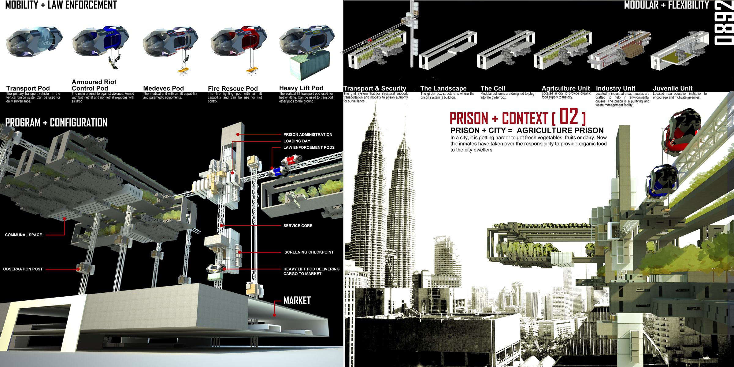
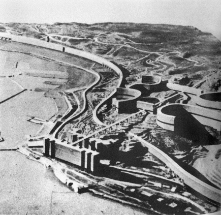
Evolo 2010 Skyscraper First Prize Entry: The Vertical Prison. Image Courtesy of Evolo
Credits: Chow Khoon Toong, Ong Tien Yee, Beh Ssi Cze
The concept of a vertical prison was
so radical it was difficult for me to comprehend back then. It became a common topic of discussion that I had with my peers for the following
semester. Those discussions soon led to our own radical and absurd ideas of
what a city needs and how it should be planned. The proposals ranges from a
floating city, an urban farm, an agriculture city and self-containing urban
city to name a few. I begin to realize that there are more than one correct method of designing and ideas, no matter how radical, should not be taken for
granted. Ironically, the Vertical Prison liberated my own design prison of a
safe and calculated approach towards design and planning. While I still believe
that there is nothing wrong of designing to the conventional method, my
interest soon diversified into other methods of designing and thinking about a
city.
Fast forward four years from my
first encounter with the Vertical Prison, my interest in urban planning and
design led to my enrolment in UDES0004 – History and Theory of Urban
Development and Design. I am hoping to enrich my knowledge on existing cities
and how it was formed as well as the concepts behind successful urban planning
and design. I believe that it is important to understand the fundamental
theories and histories in urban development in order to analyze and project the
ideas for a new blueprint in designing cities. This blog is created to document
my thoughts and progressive learnings of urban development and design as well
as to generate an outlet to write about my other interests.
Subscribe to:
Posts (Atom)