My previous post seems to end the digital journal on a light note but I guess the final entry should be on a reflection of what I have learned about cities, planning and public spaces.
First of all I begin writing this blog with thought of exploring radical ideas on the future of city planning. However, as I proceed with writing this blog, my attention turned to something that is more realistic and deals with current issues of urban planning. I guess what I have learned from my experience of writing this blog is that urban planning is not just about the urban form. It also deals with planning policies, the people, the role of citizens in urban planning, the effect of infrastructure on city planning and economic flows. As an architecture student, I enter this course with the primary objective of learning about urban forms but I end up learning more about other aspects in urban planning and the city in more ways than I could have imagined.
Writing this blog also reminded me of the problems of urban planning back in my home country of Malaysia as well as my passion for user-generated urbanism which I wrote about quite a lot in this blog. Additionally, I was able to uncover a few urban planning issues right here in Sydney. I also realized that I am interested in studying the virtual cities found in movies and compare it to cities in the real world.
I believe that the knowledge and experience I have gained through writing this blog as well as taking this course will provide a wider range of knowledge for my journey in becoming an architect. I may have left out some learning outcomes but I am sure that over time, I will come to realize that my future experience will continue to remind me the lessons I have learned through this course and assignment.
Sunday, May 25, 2014
Wednesday, May 21, 2014
New York New York
I have written quite a few posts on different cities but the
city that I would love to visit most has to be New York. The thought of New
York came to my mind while I am working on my studio assignment listening to
some music. The song “New York Minute” by Don Henley and “New York, New York”
performed by Frank Sinatra, Gene Kelly and Jules Munshin for the musical “On
The Town” played back to back on my music library. While I never had the chance
to visit New York yet, the lyrics from these songs provide some hints of what
New York might offer even after all the so many years since the release of both
songs. Both the songs depicts New York as a fast paced city where “Everything
can change, in a New York minute” and that the city has plenty of things to do.
I sure wish that this is true when I finally visit New York.
In addition to the “New York, New York” Sinatra also
performed another song of the same title.
There are plenty of other songs that is dedicated to a
particular city such as:
Friday, May 16, 2014
Density, Sprawl and Float
I find this week’s class and readings to be very
interesting. As an architecture student, I have always held the belief that the
compact and dense living in urban areas is a sustainable method of living.
While The Compact City Fallacy is a good read, I must admit that my knowledge
of sustainable living in terms of density is fairly limited and it is difficult
for me to fully agree with either side of an argument. Instead of posting an
analysis with limited knowledge on the subject area, I thought I could post
some examples of hyper-density living which I find interesting as case studies
of extreme density that makes the living condition unsafe and perhaps not
sustainable.
 |
| The Kowloon Walled City in Hong Kong |
 |
| Rocinha, the largest Favela in Brazil |
While the Kowloon Walled City and the Favelas are not the
best residential types, I find that sometimes the economic conditions or the
natural environment of the city forces the emergence of high density housing.
For example, the HDB flats in Singapore is direct consequent of the shortage of
land in the country. This made me think of examples that could solve the issue
of shortage of land. Below are videos of some examples of how it could be done.
Float!
Wednesday, May 7, 2014
Sydney vs Melbourne
During the semester break, some of my friends from Melbourne
came to Sydney for a visit. While they were here, they pointed out several
differences between the city of Melbourne and Sydney. I had the chance to stay
in both cities during my studies in Australia and most of my friends would ask
if I prefer Sydney over Melbourne. It is easy to compare the two cities as it
is very different.
First of all, Melbourne was planned based on the grid layout
whereas Sydney is more of an organic city mostly due to its topography. This
has significant effect on the two cities as Melbourne is inevitably more
structured and organized in its layout. As a result, the public transport
system in the CBD is far superior to that in Sydney.
The grid planning also makes name of the streets in
Melbourne easier to remember for me. I was only there for a year but I still
remember the names of every street in Melbourne but still having trouble with
the names of streets in Sydney. The streets in Melbourne also have very
distinct identity to it. For example, Spencer Street is the transportation hub
with Southern Cross station spanning the most part of the street. Colins Street
is home to boutiques of high fashion, Little Bourke Street is Chinatown, Lygon
Street is the food street and Swanston Street is the main street where most
international students spend their time on perhaps because it links Melbourne
University and RMIT University to most of the student residential and major
shopping complexes such as QV and Melbourne Central. On the other hand, George
Street in Sydney acts as the main spine of the city but I fail to elaborate
more on the role it plays in the CBD to my visiting friends. In addition, the
other streets around Sydney also lacks a distinctive identity to it other than
Oxford Street.
While the structured layout and clear identity in the
streets of Melbourne makes it easy to navigate and identify, it also makes it
less interesting as you know what to expect if you are to meet someone in an
allocated street. In Sydney however, it is more interesting as you can wander
around every street while still having different options in terms of activity.
Sydney feels like an interesting maze where every corner could offer something unpredictable
whereas in Melbourne, the clear mental maps makes every turn of a corner
predictable. Generally, I feel that the speed of lifestyle is much faster in
Sydney as compared to Melbourne.
The urban fabric of Melbourne ranges from all types of
colours and styles of architecture whereas in Sydney, as my friends put it, is
old and bland. Despite the less picturesque environment, I find Sydney
strangely comforting. This is perhaps the messiness and the hustle and bustle reminds
me of Kuala Lumpur. When asked to compare the two cities of Melbourne and
Sydney in a nutshell, I always compare Melbourne to me more alike to a European
city and Sydney to an Asian city. It is a fact that Melbourne is a more scenic
city but I am more accustomed to the hustle and bustle of Sydney.
The one aspect of Sydney that my friends seems to be amazed
with is the weather. They are all drawn to the clear blue skies and moderate
temperature of Sydney. I must admit that the climate is a huge factor I decided
to move from Melbourne to Sydney. While having the discussion of climate and
weather of a city with my friends, it reminded me on William Cronon’s reading
on Chicago where the natural topography and landscape plays an important role
in the development of a city. Speaking from personal experience, I believe that the natural environment
is also affects the city in terms of drawing in tourists and attracting
potential migrants to the city.
Friday, May 2, 2014
Blocking the Casbah
The situation in Cahill Expressway reminded me of a project
by Le Corbusier. The segregating form of Cahill Expressway is very much similar
to Corbusier’s masterplan in Algiers where he uses road infrastructure as a
separating component in his masterplan. While the planners for Sydney did not
intend to have Cahill Expressway to split the CBD into different components,
Corbusier did so intentionally in Algiers.
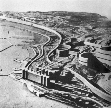 |
| Le Corbusier's masterplan in Algiers |
Corbusier’s masterplan in Algiers consisted of three main
elements as shown in the diagram below: a new business district on the Cape of
Algiers (at the tip of the Casbah) consisting of cargo ports (blue), an
elevated highway arcing connecting suburban blocks containing fourteen
residential levels beneath it towards the industrial zones (yellow) and a
curvilinear residential block with road on top of the blocks of residential
(red).

The viaduct highway connects the residential zones to the
industrial zones bypassing the Casbah beneath it. The curvilinear residential
blocks acts as a wall that separates the Casbah and the business districts.
This is done consciously by Le Corbusier to marginalize the Casbah.
Planners often think of road infrastructure as a means to
connect different points. However, we should also be aware that these huge
structures could also act as a segregating component for better or worse.
Subscribe to:
Posts (Atom)